
Another place in the park that hardly anyone visits is The Cinder Cone. While Lassen Peak itself last erupted a mere 100 years ago, this volcano has been quiet for about 400 years. A blink of an eye in geological time. Lassen and the surrounding mountains make up the southern-most end of the Cascade range. The most famous volcano in the range is Mount St. Helens and the staggering pyroclastic flow of 1980 and its most recent little burp in 2008. I remember the one from when I was a kid, but don’t remember the most recent. Lassen park is still highly active with similar features to Yellowstone although the Cinder cone isn’t one of them.

Before I get to the actual hike let’s make a few stops on the way in (yes, that’s the trail there and I did go all the way to the top).
These aspens made me stop and wander off the road with the camera. The backlighting. The shadows. It was entrancing.

There were more lovely trees on the path to the cone and I stopped for this one. The trail itself is loose ash and cinders and is like walking on the beach. It drains energy from each step and isn’t fun in hiking boots.

The back drop for this one is the edge of the lava flow that came from the cinder cone in the 1600s. Early explorers and scientists thought it was formed in the 1800s, but modern technology has pinned it at around 1650. Later in the post you can see the field from up top. It’s amazing and this is where it came to a stand still. I think the pine is a ponderosa. When we came back a couple hours later, the earth turned and the light was gone. I have learned (the hard way) to grab it immediately. Wait, and it’s gone.
Here’s the husband psyching himself up for the trek. Someone else made the pine cone heart, but I love it!

I did pause for the amazing light though. I wasn’t procrastinating though. Nope. Not me. I’m an artist!

Ok. So here we go.

It was a little difficult, but not that bad. Mostly it was the elevation and the thinning oxygen. The view was more and more incredible the higher we went. This little tree made me stop for it. Not catching my breath. No not me. I’m an artist!

And then there was the other side –

That’s Lassen Peak back there.
And I was not resting. Artist, people!
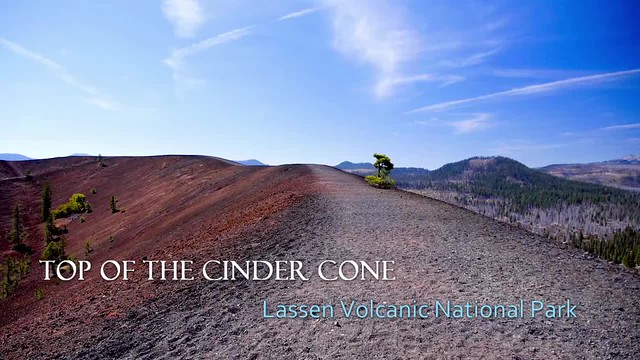
Here we are at the top. Windy as heck, but worth it. Oddly the wind was alternately cool and hot. You could definitely feel a big temperature change from gust to gust.

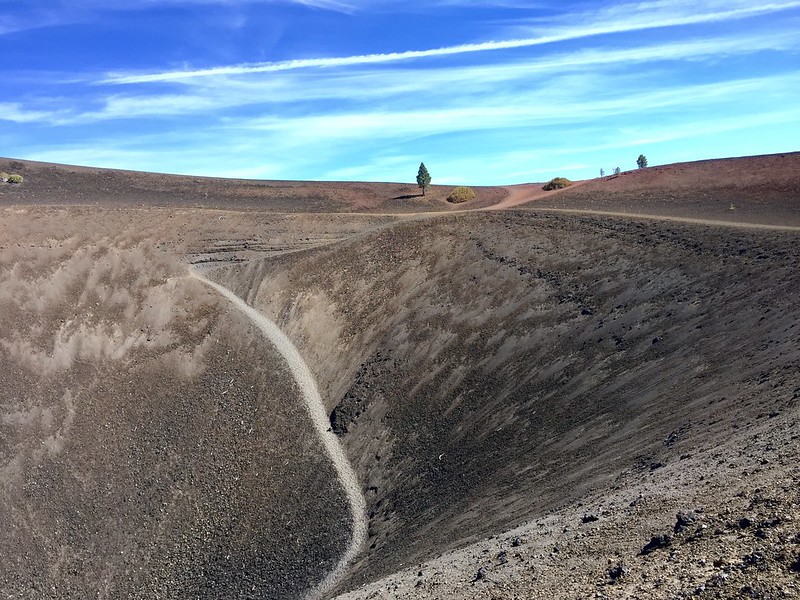
The dirt had a few different colors that were fascinating. The red is most likely iron deposits.

You can walk right down into the crater in the cone, but we didn’t since we would just have to come out again.
Here’s a quick iPhone video…sorry about the wind noise, but it couldn’t be helped. Here’s a quick video of the top. I deleted the sound because it was just wind and me breathing. No one needs that. And I haven’t gotten around to downloading any music to add to these yet.
On the backside from where the main trail comes up are views of the lava field and the painted dunes. That’s Lassen Peak in the distance (second image). You can read about the 1915 explosion here on the USGS website and see some amazing photographs of the eruption.


The light was harsh, but made for some great textures!


On the way down, I put the GH3 in the backpack and just shot with the iPhone. It was almost like hiking on marshmallow. So shifting, gentle and fun. You could almost run down in the soft cinders. They should put chairlift up and charge tickets.
Nah.
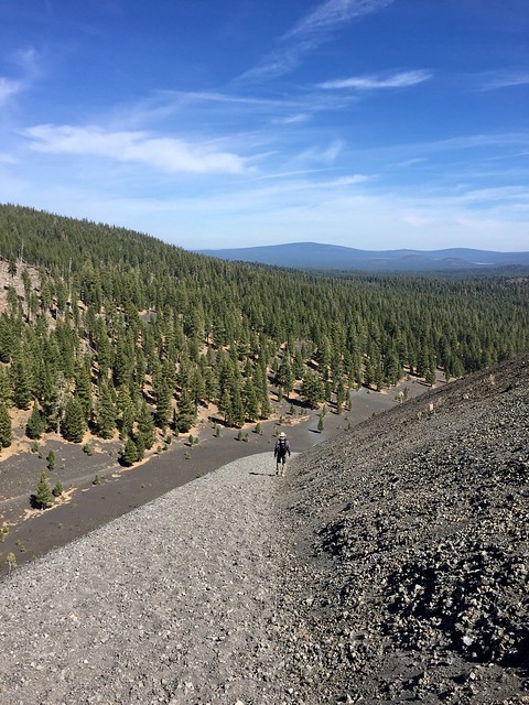
That little speck down on the bottom. That’s him again. It’s not a huge hill, but it makes everything look absolutely tiny. The base elevation is 6900 feet or so and the cone itself is only a shade under 750 feet. The path is steep though. There’s an easier way on the other side…or so people say, I didn’t look for it. To the right in the shot below you can see the lava flow and a little stripe of Butte Lake. I have a video of the dozens of butterflies on the shoreline…all looking for salt or other minerals. Or company.

So that was our other major outing at Lassen Volcanic National Park. Of course there were things we didn’t get to do. In a park this size it’s hard to see everything.
Next up…some of the other things we saw at Lassen.

Brilliant. I wouldn’t mind that hike myself. Stunning views! Thanks for sharing 👍
You’re welcome! If you ever get to Lassen, don’t miss it!
I just came across your Lassen posts. The Cinder Cone hike sounds brutal! I climbed Lassen back in 1977 when I was in my mid-30s. The trail has an average 15% grade. As I neared the top, I had to stop and breathe every few steps. I wondered what was wrong with me! Then I realized this sea-level gal was climbing to an elevation of 10,457′ where the oxygen level is about 14% compared to 20.9% at sea level (per https://hypoxico.com/pages/altitude-to-oxygen-chart).
The same thing happened to me and hubby in Death Valley – tried hiking in the mountains having just come from negative sea level and couldn’t figure out why we couldn’t breathe! When it dawned on us, we just laughed and trudged on. Lassen certainly is a jewel in the park system.
I took an August vacation to Lassen Park with my then fiancee. We camped and next morning drove to the Cinder Cone parking lot and walked to the base of the cone. It was indeed steep, and each step did drain energy, felt let each step you sunk about 3-5 inches, kinda like one step forward, two steps back. She grew weary of the hike and by the time we got to the top she declared, “I wish we were already married so I could file for a divorce.
It took us a good hour plus going up, when we started down we saw 3 young guys starting the hike up. They passed up and did the entire climb in about 20 minutes.
This was likely her first “big outdoor adventure” whereas I have been vacationing all over the Southwest for years, hiking canyons and valleys. We did get married a few years later but won’t likely be going back to Cinder Cone. We name our daughter after the park, “Lassen” and took her there when she was 18 because the park also has Conard Meadows and Mt. Conard, we hiked to both, and these were named after a distant relative who worked with the folks who were park of the early days of LVNP.
Thanks for your pictures (Artist!) and stories of the journey.
Wow – what a great story you have about this challenging, but rewarding climb. The loose ash was killer! Here’s hoping that you are still married and out having adventures together. Hubby and I still are and we remember this trip fondly.
Thanks, I took lots of pictures (color slides) we have enjoyed over the years. And yes, we are still married, in 2024 had our 8th Anniversary, daughter is now 30 in 2026. To make the math work, we married on Leap Year day in 1992. Glad you and Hubby (capitalized!) are making it work and still fond of Lassen.